In January 2012, several tribal communities from coastal Louisiana (including Grand Bayou Village, Grand
Caillou/Dulac, Isle de Jean Charles and Pointe-au-Chien Indian Tribes) met to "share knowledge, support,
cultural connectivity and adaption strategies" in response to the significant environmental changes they
are facing. This meeting, convened by the tribes and attended by the National Resources Conservation Service
(NRCS), brought together local tribal members, national tribal leaders, faith leaders, government agency
representatives, and resource specialists to share information on the various opportunities, resources, and
programs available to tribal communities experiencing the impacts of large-scale environmental change. Meeting
outcomes were documented and included as technical input for the tribal lands chapter of the 2013 National
Climate Assessment report.
Living among the bayous in southern Louisiana, these coastal tribes have experience dealing with tides, storms,
sea level changes, and soil composition fluctuations resulting from the rise and fall of Mississippi River.
However, in recent years, environmental changes including subsidence, land sinking and shrinking, and sea-level
rise have posed uncommon challenges to these indigenous communities. Natural disasters, such as Hurricanes
Katrina, Rita, Gustav, Ike, Lee and Isaac, have taken a significant toll. Additionally, the tribes have also
had to cope with various impacts resulting from the petroleum industry, ranging from standard canal construction
to large-scale disasters such as the BP oil spill. This profile explores the ways in which climate change may
exacerbate the challenges already facing coastal Louisiana tribes.
Background
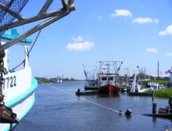
Grand Bayou Village. Photo credit: Buster Landin, Purdue University, Native American Educational and Cultural Center. Purduenaecc.blogspot.com
The Landscape:
Southern coastal Louisiana is a complex patchwork of swamps, marshes, bayous, deltas, and low-lying islands.
Fluctuations in river flow (especially the Mississippi River), tides, sea-level, storm surges, and rainfall have
historically made this an ever-changing coastal environment. However, these coastal areas are now experiencing
greater than normal subsidence and are being isolated from freshwater and sediment sources (CWPPRA). Some of
the causes of the subsidence include levee installations, fossil fuel infrastructure and extraction, and the
natural deterioration of barrier islands, which has increased the reach of encroaching marine tides and subsequently
caused erosion and saltwater intrusion that kills coastal forests. It is estimated that the mass of land loss
is equal to the size of the state of Delaware (Couvillion et al. 2011).
The Tribes:
Grand Bayou Village is a water-based tribal community located in Plaquemines Parish, LA. The Tribe has inhabited
this village for 300 years, and the broader region for much longer. They are primarily Atakapa-Ishak, with ancestry
including Acadian French and other tribes along the Mississippi River. This community continues to "live in
concert with nature", with a primarily subsistence lifestyle.
The Grand Caillou/Dulac Band of the Biloxi-Chitimacha Confederation of Muskogees is located along several bayous
that are part of the Bayou Terrebonne watershed in Terrebonne Parish, LA. The Grand Caillou/Dulac Band is a
native tribe that has lived in the region for hundreds of years.
"There used to be trees and forest for as far as you could see or run. We would go out to play and there was
land all around us, now there is just water."
Shirell Parfait Dardar, Pointe-au-Chien
The Isle de Jean Charles Band of the Biloxi-Chitimacha Confederation of Muskogees is also located in Terrebonne
Parish, LA on "a narrow ridge of land between Bayou Pointe-aux-Chene and Montegut" (called Isle de Jean
Charles). Bayou St. Jean Charles splits the island down the middle, with a road on only one side. Prior to 1876,
the State of Louisiana considered this area "uninhabitable swamp land", but then began selling to
individuals (ITEP 2008). According to oral history, the ancestors of this group first came to the island in 1840.
Since then, they have continued to preserve their community, culture, and (mixed) Indian heritage (coming from
the Biloxi, the Chitimacha, and the Choctaw tribes). Land loss is their primary concern, along with the intrusion
of saltwater affecting what little land remains, making any kind of food cultivation very difficult (NRCS Workshop
2012).
The
Pointe-au-Chien Indian Tribal Community, with approximately 680 members, is located in lower Pointe-au-Chien,
a traditional Chitimacha village in Terrebonne Parish, LA. The Pointe-au-Chien Indians have Acolapissa, Atakapas,
and Biloxi Indian ancestry. These groups have historically inhabited Louisiana and the Mississippi River Valley.
The Pointe-au-Chien continue to lead a subsistence lifestyle by hunting alligators, fishing, and catching shrimp,
crabs, and oysters, but their ability to farm is becoming more and more difficult with increasing saltwater intrusion
and land loss (NRCS Workshop 2012).
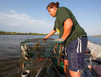
Grace Welsh, Pointe-au-Chien, collects crabs. a seafood staple of coastal tribes. Credit: Julie Dermansky (www.washingtonpost.com)
Common Challenges:
The Coastal Louisiana tribes share a common connection to the coastal landscape, having subsistence lifestyles
that are deeply rooted in local ecosystems and species. Without taking climate change into consideration, these
tribes have already been facing many challenges that compromise their ability to carry out traditional activities,
and that threaten their cultural and economic survival. As described in the NRCS Workshop 2012 Report, "The
land and waters that we depend on for our lives, our culture, [and] our heritage, have been abused, broken and
poisoned." These challenges, which result mostly from anthropogenic processes, make these tribes all the
more vulnerable in the face of climate change.
Two of the major anthropogenic contributors to tribal disparity have been the construction of levees and the
petroleum industry. The placement of levees has often negatively impacted and isolated tribal communities. These
levees, coupled with canals built by the petroleum industry, have permanently inundated previously available
land and have modified the flooding processes of the area and have reduced the natural deposition of sediment
along the coast and in the bayous that would have normally been deposited by the Mississippi River. This changes
the natural species composition of the area and affects the tribes' access to arable land, subsequently preventing
tribes from carrying out traditional and subsistence activities. This also forces tribal communities to rely on
processed foods sold in grocery stores, and thereby placing tribal members at further risk of poverty and disease.
Additionally, the BP Horizon Oil Spill had numerous impacts on local landscapes and tribal livelihoods. In 2010,
shortly after the region was finally beginning to recover from Hurricane Katrina in 2005, the BP Horizon Oil Spill
severely impacted these already vulnerable communities. The Grand Bayou Village is once again faced with the
destruction of their fishing and shrimping livelihoods as well as the damage to marshes from the encroaching
petroleum oil (Faerber, 2010). At a June 2012 GO-FISH meeting at the Houma Library, fishers told of having only
30% of their normal catch of shrimp and that all oyster beds are dead from the Atchafalaya to the Mississippi
border. Vulnerability to catastrophic events such as severe storms or oil spills hits hardest on those living
subsistence lifestyles, such as the coastal Louisiana tribes. Therefore, these events not only threaten natural
ecosystems, but they also threaten the entire way of life of these tribes.
Adding to the obstacles faced by these tribes is the fact that they have struggled to gain official State and
Federal tribal recognition. In June 2004, after many years of petitioning, the State of Louisiana granted
official State recognition to the Grand Caillou/Dulac Band and the Isle de Jean Charles Band of the
Biloxi-Chitimacha Confederation of Muskogees, as well as the Pointe-au-Chien Indian Tribal Community. The
Grand Bayou Atakapa-Ishak has not yet been recognized by the state. Additionally, all four tribes continue
to lack federally-recognized status, making it difficult to receive funding for educational opportunities,
housing improvements, or utility services, and excluding these tribes and their members from resources from
the Federal Emergency Management Agency (FEMA) and the Bureau of Indian Affairs (BIA) – all of which perpetuate
risks and vulnerability and prevent mitigation due to lack of funds (ITEP 2008). A lack of federal
recognition also leaves these tribes with little leverage to confront the entities that have negatively
impacted tribal lands and livelihoods, and also prevents the tribes from seeking federal funding to prepare
for the impacts of climate change.
Key Vulnerabilities in a Climate Change Context
The many challenges described above make Coastal Louisiana Tribes particularly vulnerable to climate change
impacts. Climate change is likely to exacerbate the effects of these pre-existing challenges. Land loss,
changes in species presence, and severe weather are all likely to become greater as a result of climate
change. Additionally, increased temperatures are already affecting the social dynamics of tribal communities.
These impacts have the potential to affect many aspects of tribal life, from the production of food to the
preservation of tribal traditions.
Land loss:
Landscape changes due to natural erosion and oil industry canals have resulted in tribal lands now covered
by water. Residents are concerned about declining land resources, loss of storm protection from once-living
forests, and decreased air quality resulting from the loss of those trees.
"I used to get lost walking in the trees behind my house. Now there's nothing. Bays and bayous
were miles from home, now they're all around" (NRCS Workshop 2012, 12).
Donald Dardar, Pointe-au-Chien
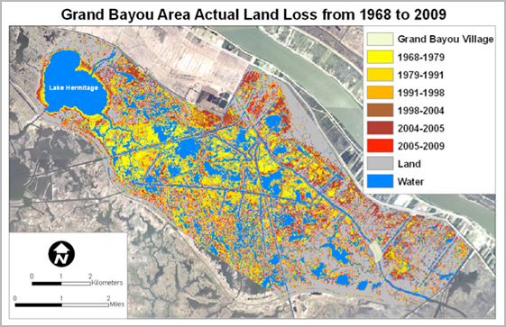
A research project completed by Bethel et al. in May 2011 confirmed, utilizing local knowledge and geospatial
mapping technology that the percentage of land in the Grand Bayou area of Plaquemines Parish has decreased
significantly. Using community members' traditional ecological knowledge (TEK), the authors produced a
report that clearly identified areas of land that have changed (mostly as a result of inundation, and to a
lesser degree, the construction of waterways) in the past 45 years. Bethel et al. concluded that these land-use
changes were a result of several environmental and anthropogenic factors including: canal dredging by oil
companies, subsidence, erosion, storms (such as Hurricane Katrina), the Mississippi River levee system (which
prevented seasonal flooding that would deposit additional sediment and help prevent subsidence), and climate
change (Bethel et al, 569).
Similarly, the Isle de Jean Charles has lost significant land. According to a PBS News Hour Broadcast,
"In the 1950s, the island was 11 miles long and 5 miles across. Now it's no more than 2 miles long and
a quarter mile across". This clear and extensive loss of land is making it difficult for residents to
continue their way of life, which includes subsistence practices such as gardening, gathering traditional
medicines and hunting wildlife historically found in this environment. Many of the residents of Isle de
Jean Charles have chosen to move away: "Eventually, when we all move off of the island and our people
move into other communities, we lose our culture, our people, our land," said Chief Naquin,
"Basically we're losing everything that an Indian tribe has" (PBS NewsHour).
Geospatial map showing land loss in Grand Bayou Area (1968-2009). Remote Sensing data was combined with the
Grand Bayou community's traditional knowledge to render this image as part of the research by Bethel et al
in 2011.
Increased Temperatures:
Coastal Louisiana tribal members have also observed increasing temperatures. Longer warm periods and shorter
winters affect plant cycles, overall ecosystem health and community dynamics. Additionally, rising
temperatures in the region impact social interactions and the sense of community. Tribal members who
attended the NRCS gathering in 2012 reported that people used to leave their windows open, which promoted
more human interaction, a stronger connection to the outdoors, and a raised awareness of natural processes
occurring outside. Now, in order to cope with the increases in temperature, many residents shut their
windows and use air conditioning instead.
One of the many "ghost forests" - dead trees that were not able to adapt to invading salt water. Image: http://bayoureference.blogspot.com/2011/06/flood-control-vs-coastal-erosion.html.
Changes in Species Presence:
Community members also point to the changes in flora and fauna species. One community describes how muskrat
trapping used to be an integral part of their lifestyle, but has now nearly ceased because there are
no longer muskrats near their homes. Other communities, such as Isle de Jean Charles, are concerned
because many of their traditional medicinal plants no longer can survive the increasing saltwater
intrusion. Bethel et al. explains,
"the new inlets and expanded waterways allowed increasing tidal
exchange and greater salinity fluctuations, which created a stressful habitat for historical vegetation
that was less tolerant of these conditions"
(567). These conditions further contribute to land loss
and erosion because the lack of vegetation allows regular tides and storms to more easily erode existing
marshland, creating a positive feedback loop of deterioration and land change. Additionally, tropical
storms (such as Lee in 2011) wreak havoc on the fragile and quickly disappearing gardens and vegetation
(NRCS Workshop 2012, 13).
Loss of Traditional Foods and Medicinal Plants
Tribal members are also concerned because they feel as if they no longer know what they are consuming. Due
to land loss and saltwater intrusion, their garden spaces are dwindling and becoming less viable for food
production. This has resulted in residents purchasing more food from the grocery store, rather than eating
homegrown vegetables.
"If there is a choice between growing potatoes on contaminated soil, it might be better than buying
them from the grocer. You don't know what kind of poison they put on them in the commercial fields."
Earl Billiot, Pointe-au-Chien
Additionally, many tribal members are no longer able to trade with other members of their community (i.e.
freshly caught shrimp for garden vegetables) (NRCS Workshop 2012). The increase in processed foods at the
expense of fresh seafood and vegetables is altering their diets and impacting their health. Yet another
concern is related to the loss of medicinal plants. Historically, tribal members found remedies for
ailments with traditional plants. Now, they must pay for medical services. Because of land changes and
the loss of traditional foods and medicinal plants, tribal lifestyles once rooted in local ecosystems and
traditional cultural practices are now disconnected and dependent on non-tribal systems.
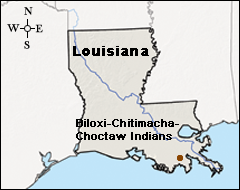
For decades, the Isle de Jean Charles off the coast of Louisiana served as a refuge for the Biloxi-Chitimacha-Choctaw
Indians. Today, their island is vanishing into the sea, leaving residents stranded without a piece of dry land to
stand on. Over the last fifty years, the island has lost all but a sliver of its landmass due to a variety of human
activities, all likely exacerbated by the impacts of climate change.
Isle de Jean Charles is a slender ridge of land between Bayou Terrebonne and Bayou Pointe-aux-Chene in Terrebonne Parish,
Louisiana. Reachable only by boat or a wagon trail that disappeared during high tides, the island was virtually cut
off from civilization until the 1950s. The island's isolation protected inhabitants from EuroAmerican settlers who
banished nearby tribes to reservations in Oklahoma. Once considered "uninhabitable swamp land" by the state
of Louisiana, the Biloxi-Chitimacha-Choctaw Indians created a thriving subsistence lifestyle on the island of trapping,
fishing, and agriculture. Their lifestyle changed little after the construction of the slim "island road"
in 1953 because it became impassable during floods or when the wind shifted. Boats remained the most reliable source
of transportation until the late 1990s when the road was elevated. This could explain why residents refer to the
community as an island, while it is, in fact, a peninsula.
Despite the tribe's geographic isolation, "There's a lot of changes that happened on the island in my
lifetime," says tribal Chief Albert Naquin. The oil and gas industry dredged canals and built pipelines that
allowed saltwater to encroach upon and destroy the freshwater wetlands that surrounded Isle de Jean Charles until
the 1960s. Besides providing crucial habitat for numerous species and other ecological services, wetlands protect
coastal areas from storm surges and prevent erosion. As the island first began to wash away into the sea, levees
constructed north of Isle de Jean Charles cut the community off from the Mississippi River and the sediment that
replenishes the land.
Steady erosion coupled with intense storms and rising sea levels has spelled disaster for the Biloxi-Chitimacha-Choctaw
Indians of the Isle de Jean Charles. The island was once 15,000 acres, but the land has been whittled away to a tiny
strip a quarter-mile wide by a half-mile long. Twenty-five houses and a couple fishing camps flank the town's single
street-down from 63 only five years ago. The rest have been washed away into the Gulf of Mexico. The Gulf's deep
blue-green waters now cover the fields and forests where this community once raised its children. With a hint of
resignation tainting his profound sorrow, tribal Chief Naquin reminisced that, "We could walk to our next town
to the east and we could walk to the next town to the west... Where my dad and I used to trap, now they go there in
boats to fish crabs."
There is no silver lining to the plight of the Biloxi-Chitimacha-Choctaw Indians, no light at the end of the tunnel.
Their island is sinking into the sea and the erosion seems to hasten by the day, the flooding worse with each storm
season. Some residents claim they loose an inch every twenty minutes. "With each hurricane, there's less and
less protection," says Chief Naquin. "Back when I was a child, we used to ride out the hurricane on the
island and not worry about flooding. We didn't have to worry about the winds either, because there were a lot of
trees... And now it's basically an open field. So when a hurricane comes, it's like here we are, come and get us."
The plight of the islanders certainly did not start with global warming. It is the result of a half-century of
irresponsible oil and natural gas extraction practices and a levee project that left the islanders at the mercy of
some of Earth's most severe storms. Yet like so many issues associated with climate change, anthropogenic ecological
disasters will likely be aggravated and hastened by a shifting climate. Scientists remain uncertain about the
correlation between tropical storms and climate change, although studies strongly suggest that the issues are
connected. Residents of Isle de Jean Charles have noticed a change, particularly after Hurricane Betsy in 1965.
Since becoming chief in 1997, Naquin too thinks the storms have intensified. He speaks the names of the worst
storms with intimate familiarity--Lili, Ivan, Katrina, Rita, Wilma, Gustav, Ike--no doubt remembering the hardships
each has caused.
Beyond the storms, the sea level is simply higher than it used to be. The US EPA reports that sea levels in the
Gulf Coast region rose five to six inches over the global average during the last century. The Intergovernmental
Panel on Climate Change 2007 report predicts that the sea will continue to rise another 0.6 to 2 feet by the turn
of the next century due to melting glacial ice, as well as warmer ocean temperatures. Warm ocean temperatures are
also a major factor in the development of tropical storms. The tides, too, are quite literally changing. Naquin
reports that water levels from high- to low-tide change "maybe two feet within an hour." When he was a
child, they varied by six inches. Their island road, elevated less than a decade ago, is cut in half during high
tide; boats may again be the only way to reach what is left before it's gone completely.
While scientists are still uncertain about the magnitude of the impacts of climate change, one thing is certain:
the Biloxi-Chitimacha-Choctaw Indians of the Isle de Jean Charles are in trouble. It is too late to save the
island, says Naquin. "It's like you have a cancer and you don't do nothing about it, and then by the time
you do something about it it's too late... We've basically lost all our land. It's basically gone." The final
hope died in 2002 when the Army Corp of Engineers decided to route a new 72-mile levee constructed as part of the
Morganza to the Gulf Hurricane Protection Project around the island due to cost constraints. The Corp of Engineers
proposed re-locating the entire community, but some residents refused to leave. Without 100 percent participation,
the Corp dropped the offer. "The help now," the Naquin says, "in minimal."
To further complicate the issue, the tribe lacks federal recognition, making residents ineligible for federal
assistant from the Federal Emergency Management Agency (FEMA) and the Bureau of Indian Affairs (BIA). According
to Naquin, "The red tape from being federally recognized is very, very red... They [the BIA] know we're
Indians. We know we're Indians, but they just won't give us recognition because we don't have the proper historical
records... Maybe they just don't want any more Indians." Thus, unlike Alaska Native Villages like Newtok,
federal and state assistance will likely never come.
The choice to flee a sinking island and head to higher ground may seem easy, but with few resources to re-locate
and an intimate connection with the land, residents are holding on to what's left. Many lack a formal education-the
one room schoolhouse was closed fifty years ago-and remember the bounty they once had on the sliver of land in
the middle of a Louisiana bayou. The Isle de Jean Charles holds the stories of their Elders, the bones of their
ancestors, and the fabric of their culture. The Biloxi-Chitimacha-Choctaw Indians of the Isle de Jean Charles
are fishermen. Leaving the island means leaving their world to vanish into the sea-and some are not quite ready
to make that choice.
Tribal Climate Change Profile Project:
The University of Oregon and the USDA Forest Service Pacific Northwest Research Station are developing tribal climate change project profiles as a pathway to increasing knowledge
among tribal and non-tribal organizations interested in learning about climate change mitigation and adaptation efforts. Each profile is intended to illustrate innovative approaches
to addressing climate change challenges and describes the successes and lessons learned associated with planning and implementation. For more information about the initiative, visit:
http://tribalclimate.uoregon.edu/.
Natasha Steinman and Kirsten Vinyeta contributed to this profile. Natasha is a fourth-year Environmental Studies student at the University of Oregon and a student research assistant
with the Pacific Northwest Tribal Climate Change Project. Kirsten is a second-year Master’s student in Environmental Studies at the University of Oregon and the graduate research
fellow with the Pacific Northwest Tribal Climate Change Project.

 Grand Bayou Village. Photo credit: Buster Landin, Purdue University, Native American Educational and Cultural Center. Purduenaecc.blogspot.com
 Grace Welsh, Pointe-au-Chien, collects crabs. a seafood staple of coastal tribes. Credit: Julie Dermansky (www.washingtonpost.com)
 Geospatial map showing land loss in Grand Bayou Area (1968-2009). Remote Sensing data was combined with the
Grand Bayou community's traditional knowledge to render this image as part of the research by Bethel et al
in 2011.
Geospatial map showing land loss in Grand Bayou Area (1968-2009). Remote Sensing data was combined with the
Grand Bayou community's traditional knowledge to render this image as part of the research by Bethel et al
in 2011.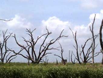 One of the many "ghost forests" - dead trees that were not able to adapt to invading salt water. Image: http://bayoureference.blogspot.com/2011/06/flood-control-vs-coastal-erosion.html.
 For decades, the Isle de Jean Charles off the coast of Louisiana served as a refuge for the Biloxi-Chitimacha-Choctaw
Indians. Today, their island is vanishing into the sea, leaving residents stranded without a piece of dry land to
stand on. Over the last fifty years, the island has lost all but a sliver of its landmass due to a variety of human
activities, all likely exacerbated by the impacts of climate change.
For decades, the Isle de Jean Charles off the coast of Louisiana served as a refuge for the Biloxi-Chitimacha-Choctaw
Indians. Today, their island is vanishing into the sea, leaving residents stranded without a piece of dry land to
stand on. Over the last fifty years, the island has lost all but a sliver of its landmass due to a variety of human
activities, all likely exacerbated by the impacts of climate change.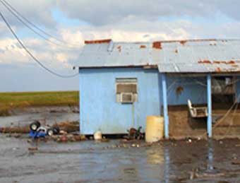 Steady erosion coupled with intense storms and rising sea levels has spelled disaster for the Biloxi-Chitimacha-Choctaw
Indians of the Isle de Jean Charles. The island was once 15,000 acres, but the land has been whittled away to a tiny
strip a quarter-mile wide by a half-mile long. Twenty-five houses and a couple fishing camps flank the town's single
street-down from 63 only five years ago. The rest have been washed away into the Gulf of Mexico. The Gulf's deep
blue-green waters now cover the fields and forests where this community once raised its children. With a hint of
resignation tainting his profound sorrow, tribal Chief Naquin reminisced that, "We could walk to our next town
to the east and we could walk to the next town to the west... Where my dad and I used to trap, now they go there in
boats to fish crabs."
Steady erosion coupled with intense storms and rising sea levels has spelled disaster for the Biloxi-Chitimacha-Choctaw
Indians of the Isle de Jean Charles. The island was once 15,000 acres, but the land has been whittled away to a tiny
strip a quarter-mile wide by a half-mile long. Twenty-five houses and a couple fishing camps flank the town's single
street-down from 63 only five years ago. The rest have been washed away into the Gulf of Mexico. The Gulf's deep
blue-green waters now cover the fields and forests where this community once raised its children. With a hint of
resignation tainting his profound sorrow, tribal Chief Naquin reminisced that, "We could walk to our next town
to the east and we could walk to the next town to the west... Where my dad and I used to trap, now they go there in
boats to fish crabs."