Great Lakes
The Bad River Band of Lake Superior Chippewa (Ojibwe) is nestled on the southern shore of Lake Superior in northern Wisconsin. Established by the 1854 Treaty of La Pointe, the Bad River Reservation is the largest
in the state, totaling 124,654 acres, with 38 miles of shoreline along Lake Superior and nearly 200 miles of rivers and streams criss-crossing the land.
Wetlands of International Importance
Covering over 10,000 acres of the Bad River Reservation, the Kakagon and Bad River Sloughs were designated as Wetlands of International Importance, otherwise known as a Ramsar Site (
https://www.ramsar.org/sites-countries/the-ramsar-sites), in 2012.
This made the Sloughs the first Ramsar Sites to be owned by a tribe.
The importance of these wetlands runs deep, spiritually, culturally, and ecologically. They are the largest wetland complex in the Lake Superior Basin and are tied to the tribe’s history and culture as wild rice harvesting beds.
Elders of the tribe recall going out as children and seeing wild rice standing far above their heads. In recent years, a dramatic decrease in the amount of rice being produced has been seen. This decrease has been tied to an
increase in weather pattern variability, which is anticipated to increase with climate change. Wild rice has been designated in the Great Lakes Indian Fish and Wildlife (GLIFWC) commission’s Climate Change Vulnerability Assessment
as either highly or extremely vulnerable to climate change based on a broad body of research. Wild rice has a stage in its life cycle where it is particularly delicate and prone to damage from both flooding and very low lake levels.
Such extreme changes are becoming increasingly frequent.
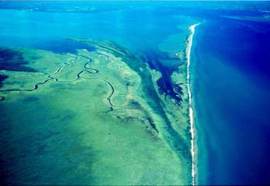 Bird’s eye view of the Sloughs. Photo courtesy of Jim Meeker
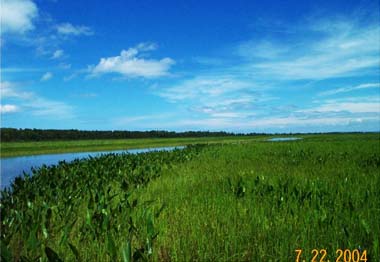 Wild rice growing in the Sloughs. Photo courtesy of the Bad River Natural Resources Department.
Unprecedented Flooding
Although this area has historically seen flooding events, extreme and more frequent flooding began in the region in 2010. Then, in July 2016, a historic storm pummeled the Bad River Reservation. Ten to twelve inches
of rain fell in an eight-hour period, causing $25 million worth of damage to roadways, bridges, and other infrastructure. Parts of the Reservation that had been a five-minute drive away from each other now took six
hours to access. Damage to infrastructure also impacted tribal members’ abilities to hunt and fish off reservation and exercise their harvesting rights, including harvesting wild rice, in ceded territories.
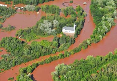 Aerial photo of the 2016 flood. Photo courtesy of the Civil Air Patrol.
Infrastructure as a Solution
According to the Fourth National Climate Assessment, “climate projections suggest an increased risk of inland flooding,” in this region. The Bad River Tribe realizes the importance of establishing mechanisms for disaster
preparedness in response to future flooding events. Everything is viewed through the lens of protecting the Tribe’s cultural and natural resources, such as the wetlands and wild rice. To that end, the Tribe approved a
Seventh Generation Climate Monitoring Plan, which addresses climate change projections and impacts, a monitoring approach, and adaptation strategies, and was written in accordance with their tribal customs and beliefs.
In addition to working jointly with the Water Resources Specialist and other entities within the tribe to assist in decision making and monitoring efforts targeting wild rice (for example, by helping to inform the tribe
on how the effects of climate change may impact the viability of wild rice in the future), the Seventh Generation Climate Monitoring Plan precipitated the two primary focus areas of the Natural Resources Department’s
Climate Change Program: 1) culvert replacement, stormwater infrastructure improvements, and erosion control to prepare for more frequent flooding events; and 2) partnering with the Tribal Historic Preservation Office to
prepare designated historical sites on the Reservation for the anticipated changes in flood patterns. Culvert replacement is primarily meant to improve resistance and resilience against extreme precipitation events and
flooding. Certain culvert replacements can improve aquatic organism passage and general hydrology, potentially bolstering the health of wetlands both above and below the culvert.
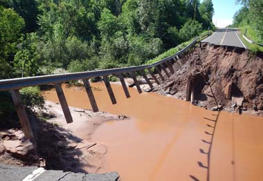 Road damage from 2016 flood. Photo courtesy of the Bad River Natural Resources Department.
Challenges and Strengths
Funding for the culvert and infrastructure projects has come from the Environmental Protection Agency’s Great Lakes Restoration Initiative, and funding to protect important historical sites has come from the National Park Service’s
Historic Preservation Fund grants. However, funding shortfalls remain the Tribe’s biggest challenge in implementing such projects, since infrastructure is extremely costly.
One of the Bad River Tribe’s greatest strengths lies in their communication and cooperation both within the Natural Resources Department and with neighboring tribes. For example, the region is frequently targeted by mining companies
who are interested in opening new mining sites. By working with other tribes, they have put forth a concerted effort to make sure environmental interests are followed and recognized. This has clear crossovers for the Tribe in
mitigating and adapting to climate change: working together brings a far more effective level of response than working alone. Within the Natural Resources Department, there is collaboration between the Environmental Program, the
Climate Change Program, and the Tribal Historic Preservation Office, again highlighting the effectiveness of working together.
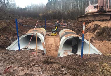 Culvert replacement. Photo courtesy of Eric Andrews.
Climate Change Adaptation Across Programs
The Bad River Tribe recognizes other areas of need in their climate change adaptation planning as well. The Air Quality Program has partnered with the Natural Resources Conservation Service (NRCS), who operates the Soil Climate Analysis Network (SCAN)
https://www.wcc.nrcs.usda.gov/tribalscan/tribalscan_brochure.pdf across the country to measure soil moisture and soil temperature as well as a full suite
of meteorological sensors. By combining real-time soil data and weather conditions, SCAN stations support agricultural decision-making regarding field operations as well as greater forecasting confidence for agricultural adaptation or transition decisions
that are critical to increased resilience during times of extreme weather events. Because SCAN is integrated into the wider weather station network in the region, and because the data is integrated into a portal, it is not only helpful in making
decisions based on changing weather patterns, but is also a powerful educational tool for students to look at how data is collected, science is utilized, and information is processed.
SCAN has a wide variety of important applications for the Bad River Tribe, including filling locational data gaps in both air quality monitoring and in severe winter temperatures that impact wildlife, monitoring forest drought stress,
and emergency management for flooding. It also may aid in predicting events and circumstances that have the potential to damage wild rice. In 2007, Lake Superior reached record low levels in the middle of a several-year drought across
the western Great Lakes. For the first time in memory the Bad River community was unable to harvest wild rice due to extremely low water conditions that led to a drastic reduction in wild rice production that year in areas that are
traditionally the best harvest areas on the Reservation. Then in 2012, a very large flooding event hit Duluth, Minnesota, and Superior, Wisconsin, west of the Reservation. While the flooding event was not catastrophic in the Bad River
watershed, it is believed that the heavy rains hit at the most vulnerable stage in the life cycle of wild rice when the rice is young and fragile enough that strong currents can break off the wild rice plants from their anchor below
the water, washing most of the young wild rice out of the sloughs and Bad River into Lake Superior. While some wild rice survived in 2012, the harvest was suspended to allow any remaining wild rice to reseed itself following such a
large impact on the plants. For the second time in recent memory, the Bad River community went without a wild rice harvest. While some wild rice is sold after harvesting, much of it is reserved for feast events such as funerals or as
a vital food source for many families. Tracking long-term drought with the precipitation gauge and soil moisture probes may be useful for resources like wild rice, and while flooding is of course a concern, even heavy precipitation
with soil moisture information may help the Tribe predict if rainfall will run off and increase the river levels, or soak into the soil instead.
Separately, the Bad River Tribe’s Forestry program is partnering with the U.S. Forest Service’s Northern Institute of Applied Climate Science (NIACS) and with BIA’s Brand of Forest Resources Planning to address climate change adaptation
to promote healthy forests in the face of changing conditions such as rising temperatures and changing precipitation patterns. The focus is on creating a healthy and diverse succession of trees to enhance forest resilience.
https://climateframework.org/sites/default/files/BadRiver_AdaptationProject_Highlights.pdf
Through collaboration, foresight, and deep data analysis, the Bad River Band of Lake Superior Chippewa is preparing for a stormier future.
Resources
Angel, J., C. Swanston, B.M. Boustead, K.C. Conlon, K.R. Hall, J.L. Jorns, K.E. Kunkel, M.C. Lemos, B. Lofgren, T.A. Ontl, J. Posey, K. Stone, G. Takle, and D. Todey, 2018: Midwest. In Impacts, Risks, and Adaptation in the United States:
Fourth National Climate Assessment, Volume II [Reidmiller, D.R., C.W. Avery, D.R. Easterling, K.E. Kunkel, K.L.M. Lewis, T.K. Maycock, and B.C. Stewart (eds.)]. U.S. Global Change Research Program, Washington, DC, USA, pp. 872–940. doi: 10.7930/NCA4.2018.CH21
This profile was developed in 2019 by Dara Marks-Marino, Institute for Tribal Environmental Professionals, Northern Arizona University, with financial support from the Bureau of Indian Affairs. The profile is available on the Tribes & Climate
Change website:
www7.nau.edu/itep/main/tcc/Tribes. The tribal climate change profiles featured on the website are intended to be a pathway to increasing knowledge
among tribal and non-tribal organizations interested in learning about climate change mitigation and adaptation efforts.
Special thanks to Eric Andrews and Nathan Kilger for their assistance in developing this profile.
For more information please contact:
Citation: Marks-Marino, D. (July 2019) The Bad River Band of Lake Superior Chippewa (Ojibwe), July, 2019. Climate Change Program, Institute for Tribal Environmental Professionals, Northern Arizona University.
Available at:
www7.nau.edu/itep/main/tcc/Tribes/gl_badriver