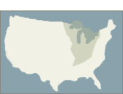
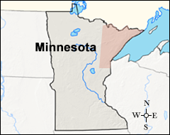
Treaties and Ceded Territories
The 1854 Treaty Authority is an inter-tribal resource management agency governed directly by the federally recognized Bois Forte Band of Chippewa
and Grand Portage Band of Lake Superior Chippewa. The organization is charged with preserving, protecting, and enhancing treaty rights in the 1854 Ceded Territory. Inherent in these reserved rights is the necessity to
protect the waters, air, animal and fish populations, wild rice, forest products, and other resources that are essential to the Ojibwe culture and way of life. Under the Treaty of 1854,
Bands retain rights to hunt, fish, and gather in the 1854 Ceded Territory. This Ceded Territory encompasses 5.5 million acres of land in what is now considered present-day northeastern Minnesota.
The term “ceded territories” refers to the “lands transferred from tribes to the federal government by way of a treaty agreement.” By ceding land to the United States, tribes are guaranteed rights to harvesting, hunting,
and fishing. More often than not, tribes that signed treaties did so under extreme duress, coercion, and disadvantaged power. The legal interpretation of the rights of the treaties has been examined in the Supreme Court
since the inception of the treaties and continues today. Further, there are many misconceptions and misunderstandings from the general public about what those rights entail.
Organizations such as the 1854 Treaty Authority work to ensure that tribes can exercise and enforce their rights, and serve to collaborate with federal and state agencies to uphold the treaties. The 1854 Treaty Authority
has a board of directors, which is made up of five tribal council members from each Band and gives direction on topics such as setting seasons for hunting and fishing and limits on the amount of game that can be taken.
They utilize conservation officers to enforce a conservation code, and take part in environmental reviews on anything that will impact the access to or availability of resources. Mining activity in the Ceded Territory
is the primary impact that requires environmental reviews, along with other land management practices and decisions that lead to a change in ownership and access.
Climate Change Knows No Boundaries
Tribal members, elders, and harvesters in the area have observed changes in wild rice and moose populations. Fewer moose are being observed within the 1854 Ceded Territory as winter and summer air temperatures increase, causing
thermal stress and other indirect impacts, and storms seem to be impacting wild rice availability and harvest. Heavy wind events seem to be occurring more frequently throughout the summer months, bending stalks and knocking
off the seeds; and heavy rain is occurring more frequently in the early growing season, drowning and uprooting the plants.
A few years ago, the 1854 Treaty Authority recognized the need to address climate change, but were unsure where to begin due to the nebulous nature of climate change. The Grand Portage Band had a Vulnerability Assessment and
Adaptation Plan nearly completed for their Reservation, so the 1854 Treaty Authority looked to them during initial conversations. They also opened conversations with the Bois Forte Band’s resource management department, as
well as with the Fond du Lac, which is another Band of Lake Superior Chippewa that has treaty reserved rights within the
1854 Ceded Territory. Since all the parties had the same goals in mind and the same treaty area of interest, they decided to collaborate equally as partners to develop a
Climate Change Vulnerability Assessment and Adaptation Plan: 1854 Ceded Territory Including the Bois Forte, Fond du Lac, and Grand Portage Reservations (Plan).
Vulnerability assessment workshop hosted at the 1854 Treaty Authority office in October, 2015.
Climate Change Vulnerability Assessment and Adaptation Plan
The Plan built on the work that Grand Portage had already completed, and was funded through a grant from the Bureau of Indian Affairs (BIA) Tribal Climate Change Adaptation Grant Program. The Bands and the
1854 Treaty Authority had direct oversight and input into the Plan, but hired contractors to help create the process for developing the Plan, strengthen the Plan with climate science, do the technical writing,
facilitate calls and meetings, and in general keep the process moving forward. From start to finish, the Plan took just over one year to complete, culminating in 2016.
There were three main phases in the creation of the Plan: 1) completing a climate assessment for the Ceded Territory, including both current and predicted changes; 2) developing a vulnerability assessment,
which consisted of holding a workshop and phone calls with nine resource category workgroups; this was the longest part of the process as it addressed over 30 resources/resource groups; and 3) developing
adaptation strategies for each resource, totaling 269.
Implementation
Although each of the three Bands and the 1854 Treaty Authority has the same Plan, there are differences in how and which strategies will be implemented within each Reservation and the Ceded Territory. The 1854 Treaty
Authority has prioritized the strategies that pertain specifically to the Ceded Territory based on the timing of the action, ease of implementation, costs, and the number of partners that each requires.
Tansey Moore (former 1854 Treaty Authority Climate Change Specialist) installing a phenocam on a wild rice water in spring, 2017.
Still image of wild rice from the phenocam on Stone Lake on July 2, 2017.
Image of acoustic recorder used to monitor timing of frog and toad calling.
Image of temperature logger set-up before deployment into a walleye assessment lake.
Illustration of a temperature and dissolved oxygen logger chain design. Small black loggers record temperature and the large gray/black logger records temperature and dissolved oxygen.
Currently, the main focus of the 1854 Treaty Authority’s implementation plan is the expanded monitoring of vulnerable resources. Many of the following strategies are intended to enhance the data already
being collected, which can then be shared among agencies to identify trends and determine if there are relationships with climate change. Another focus of the implementation plan is on outreach and
education for Bois Forte and Grand Portage Band members, as well as other tribes, tribal organizations, the general public, universities, and state and federal agencies.
Wild rice phenology. Of the ten lakes they were already monitoring, the 1854 Treaty Authority has added a phenocam to two of them. A phenocam is a camera that is used to monitor the phenology - or
the seasonal changes - using time-lapse photos. The phenocams are placed before the ice goes off the lake in the spring, and removed months later when the ice is back on the lake. Periodic visits are
made to check the phenocams throughout the open water season. In this way, they can monitor the changes in timing of how the wild rice develops. Additionally, they do bi-weekly checks on rice
development, water level, and surface temperature, and perform density surveys on each lake once per year. Some possible ties to climate change that have been observed are the presence of rice worm
which makes the grains unharvestable (and has always been present, but they are monitoring for changes along with the climate); and the presence of brown spot (which is a fungal disease that can
develop on wild rice, especially with warmer and more humid nighttime conditions). Discoveries through monitoring may not change the management of wild rice, but it is important information that ties
into developing accurate outreach and information for people.
Maple sap collection. The 1854 Treaty Authority is working with sap collectors in the area, in order to build a bigger network to look at the timing and duration of the seasons. Because the flow of
sap from sugar maples is dependent on the freeze/thaw cycles of springtime, climate change may greatly impact the yields, timing of the season, and quality of the production.
Acoustic recorders. The 1854 Treaty Authority has been monitoring the timing of frog and toad calling and how that has been changing in the springtime. As part of the implementation plan, they are
looking into developing better methods for analyzing the data collected.
Water temperature monitoring. Using lakes already being assessed for walleye by the 1854 Treaty Authority and Fond du Lac Band, temperature monitors have been added to look for trends in surface
water temperatures. The monitors are deployed early in spring and taken out in the fall.
Stratification and dissolved oxygen water monitoring. Using a vertical line/chain of temperature and dissolved oxygen monitors that are submerged in Lake Vermilion year round, the 1854 Treaty
Authority is starting to monitor for changes in stratification and oxygen availability in the water column.
Ice conditions. Using a variety of ten lakes (some of which are wild rice lakes, some are walleye lakes, and some have good ice duration data) that are spread from north to south through the Ceded
Territory, the 1854 Treaty Authority goes to the same location on each lake monthly during winter, drills a hole, and measures the thickness of the ice. They record how much of the ice is solid and how
much is slush, as well as the snow depth both on the ice and on the shore. They are tracking this information to identify any trends, such as less ice in the wintertime. They can also cross-reference
this information with Minnesota’s Department of Natural Resources website that tracks ice conditions from observations, helping to identify changes in duration of ice cover.
Moose population survey. This is an annual flight survey conducted by the state of Minnesota, Fond du Lac Band, and the 1854 Treaty Authority to estimate the density of moose in northeastern Minnesota.
This information is used to inform management planning.
Rain barrels. From 2015-2018, 95 rain barrels were purchased with funding through the BIA Tribal Resilience Program and donated to interested members from the Bois Forte and Grand Portage Bands.
This was a great way of engaging Band members to talk about climate change and help them reduce water use and runoff, especially for larger gardens.
Tyler Kaspar (1854 Treaty Authority Environmental Biologist) measuring ice thickness on Round Island Lake in January, 2018.
Aerial image of a bull moose taken during the annual moose survey in northeastern Minnesota.
Strengths, Challenges, and Lessons Learned
The Climate Change Vulnerability Assessment and Adaptation Plan is a critical document for developing an understanding of changes that are occuring, finding consensus in the community as to what needs to be done, and providing
management actions to address these changes. Impressively, solid consensus was achieved among the partnering Bands and 1854 Treaty Authority while developing this Plan.
As an inter-tribal organization, the 1854 Treaty Authority has a good relationship with other co-managers, and is able to be at the table to talk about climate change and other management issues in partnership. The Plan is an
additional tool they have in their toolbox to open communication with land managers, while keeping in mind treaty rights, responsibilities to tribes, and the availability and health of resources. That said, it is challenging to
not be the primary land manager. It requires substantial coordination and communication to implement actions and decisions that are ultimately up to the state and federal land management agencies. Often, concerns are heard but
not acted upon by state and/or federal agencies. Additionally, the Ceded Territory covers a large expanse of land, so priorities have to be set.
During the process of developing the Plan, they learned that there is more than one way to bake a cake, and sometimes trial and error is the unintentional magic ingredient. Being clear and up front about expectations is a great
approach, but sometimes you do not know what your expectations are until you have an experience that highlights what you do not want! Additionally, funds and timelines are usually limiting factors, and since it is nearly impossible
to know from the beginning how much can be accomplished within those guidelines, it is important to have the flexibility to narrow the scope as needed.
The 1854 Treaty Authority is an integral and indispensable agency for ensuring the Bois Forte and Grand Portage Bands have well-managed lands and their rights to those lands remain protected. Cooperatively developing the Climate
Change Vulnerability Assessment and Adaptation Plan with the Bois Forte, Grand Portage, and Fond du Lac Bands has elevated their capacity to continue to fulfill this critical role.
This profile was developed in 2019 by Dara Marks-Marino, Institute for Tribal Environmental Professionals, Northern Arizona University, with financial support from the Bureau of Indian Affairs. The profile is available on the Tribes & Climate
Change website: www7.nau.edu/itep/main/tcc/Tribes. The tribal climate change profiles featured on the website are intended to be a pathway to increasing knowledge
among tribal and non-tribal organizations interested in learning about climate change mitigation and adaptation efforts.
Special thanks to Tyler Kaspar for his assistance in developing this profile.
Citation: Marks-Marino, D. (October 2019) 1854 Treaty Authority, Institute for Tribal Environmental Professionals, Northern Arizona University.
Available at: www7.nau.edu/itep/main/tcc/Tribes/gl_trAuth

 Treaties and Ceded Territories
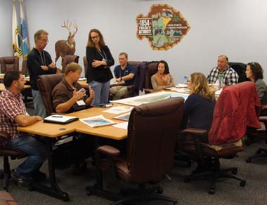 Vulnerability assessment workshop hosted at the 1854 Treaty Authority office in October, 2015.
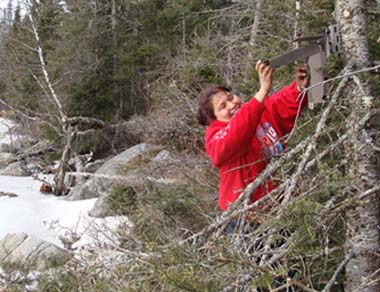 Tansey Moore (former 1854 Treaty Authority Climate Change Specialist) installing a phenocam on a wild rice water in spring, 2017.
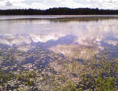 Still image of wild rice from the phenocam on Stone Lake on July 2, 2017.
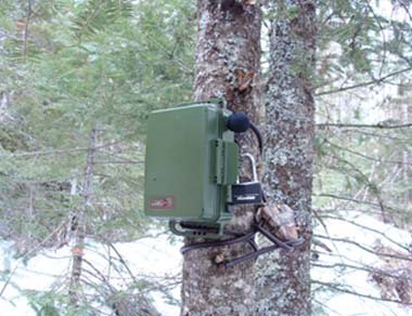 Image of acoustic recorder used to monitor timing of frog and toad calling.
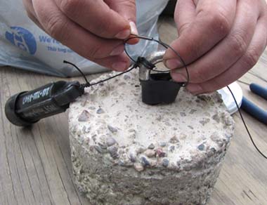 Image of temperature logger set-up before deployment into a walleye assessment lake.
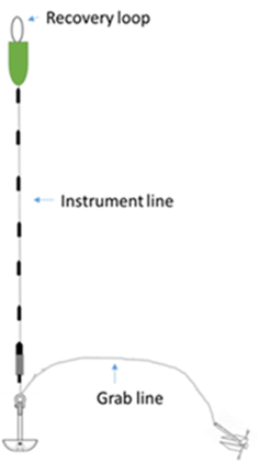 Illustration of a temperature and dissolved oxygen logger chain design. Small black loggers record temperature and the large gray/black logger records temperature and dissolved oxygen.
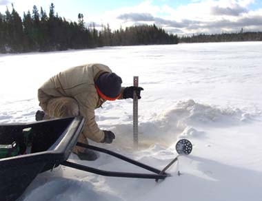 Tyler Kaspar (1854 Treaty Authority Environmental Biologist) measuring ice thickness on Round Island Lake in January, 2018.
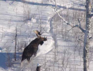 Aerial image of a bull moose taken during the annual moose survey in northeastern Minnesota.